Hiking near Col de la Bonette: Cime de Pelousette 2757 m
We have previously reported a moderate 4 hour day hike to Col de la Cavale from Camp des Fourches (2240 m) just before Col de la Bonette (2715 m) mountain pass.
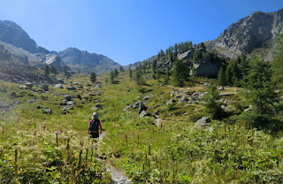
Today’s hike to Cime de Pelousette (2757 m) and back takes about 3 h. The trail first ascends in alpine meadows followed by some rocky parts. Because of the altitude, the whole route is above the tree line. On a clear day like ours, navigation is easy. Even so, there are many man and animal made trails crisscrossing the terrain, hence follow the trail marked with yellow and cairns! Views are stunning all the way.
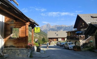
The barracks at Camp des Fourches were occupied all year round until the end of WWII. It is difficult to imagine the life of mountain infantrymen, chasseurs alpins, as the area is covered by snow 2/3 of the year. The road is open only during the summer months.
From signpost 41, the trail forks left (north). It is not necessary to walk as far as to Col des Fourches nearby. A grassy small mountaintop called Ventabren is passed, leaving it on the right hand side of the trail. After this, the path turns to northwest climbing more steeply in rocky terrain before it levels off slightly and turns south west for about 400 m. Another steeper climb follows, and just under the summit the trail climbs straight north again before reaching the mountain crest called Crête de la Tour. From the crest, our summit is reached in just a few minutes. During the ascent, the summit of Cime de Pelousette is not actually visible as the southern flank is round, comprising alpine meadows. The northern and western flanks are, on the other hand, very steep and rocky. Don’t go inside the fortress ruins, the structures are fragile. From the summit, you can see the RM 64 road climbing up to Col de la Bonette. Cime de la Bonette (2860 m) is clearly visible in distance, also the loop road (2802 m) circling the mountain. It is said to be the highest paved road in the Alps connecting two regions.
We returned to our starting point along the same trail.
A rewarding high-altitude hike that requires little effort!
Vertical climb: 520 m
Duration: 3 h
Map: IGN 3639 OT Haute Tinée 1
Distance from Nice 102 km
Image of trail courtesy of Google Maps


