Mont Capelet Inférieur Hike
 |
Situated above the Gordolasque Valley inside the Mercantour National Park, Mont Capelet Inférieur (2419 m) does not have any marked trails to the summit in the official hiking maps. The mountain is nevertheless easy to reach from the Gordolasque Valley. The grassy southwestern face is a bit steep but nice to ascend. The neighbouring Cime du Diable (2865 m) and Mont Capelet Supérieur (2637 m) are both steeper and rockier.
NB! There is limited access to the Gordolasque Valley for vehicles under 3,5 t. The RM171 road was initially closed after the devastating storm named Alex in early October 2020.
For updated info in the Vésubie Valley:
https://www.nicecotedazur.org/actualite/2020/10/21/temp%C3%AAte-alex-point-de-situation-quotidien
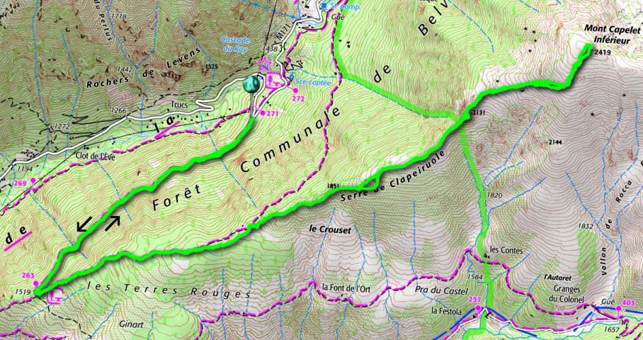
We drove to Bélvèdere in the Vésubie River Valley, then followed the narrow M171 in the Gordolasque Valley, and parked next to signpost # 271 at 1380 m (a sharp bend just after Cascade du Ray waterfall), showing directions to Crêtes des Terres Rouges; Serre de Clapeiruole.
We hiked southwest along a good dirt track and after 2 km came to a clearing at 1519 m. Here, at signpost # 263, we forked left (east) into the woods and ascended along a nice path in Terres Rouges. Gradually, the forest was replaced by Alpine meadows. There were yellow markings as far as to a meadow with a telecom mast. The marked trail descended back to the Gordolasque Valley (St-Grat) from here. We continued straight, staying on the ridge called Serre de Clapeiruole. There was a barely visible trail in places, and small cairns here and there.
We reached the border of Mercantour National Park, marked with two large green dots. Here we climbed straight on. After a short albeit steep ascent, we came to another flat Alpine meadow between two sharp cliffs. We now had the southwestern flank of Mont Capelet Inférieur in front of us.
We climbed quite steeply along the soft mountain slope, heading approximately northeast, then turned gradually north to the summit.
A big cairn marked the highest point in the middle of the summit plateau. The nearby Diable and Capelet Supérieur dominated the landscape in the east but we had a 360° panorama of 3000+ Mercantour peaks near the Italian border.
We headed back using the same itinerary. Our return route was easier to see from above, notably the section that went between the two cliffs (image with arrow). On either side of these, the terrain was quite steep and rocky.
Distance: 13 km
Climb: 1040 m
Duration: 5 h 20
Map: Vallée de la Vésubie 3741 OT
 |
| Mont Capelet Inférieur trail track |
 |
| Gordolasque Valley location |


0 comments:
Note: only a member of this blog may post a comment.